"Walking distance to shops" is doing a lot of work in that listing. Depending on who wrote the ad, it can mean 200 metres or 2 kilometres, and there is no rule that says which. One of those is a stroll for the milk. The other is a 25-minute one-way commitment you will make exactly twice before driving.
Walkability is measurable. Most of what is written about it in property marketing is vibes. So how do you actually check it before you sign a contract?
The short version
| Reading the listing | Walking it yourself | Walk Score | Google Maps checks | Modelled score | |
|---|---|---|---|---|---|
| Cost | Free | Free, plus a Saturday | Free | Free | Free |
| What you get | Marketing copy | Ground truth, one address | A well-known 0-100 benchmark | Real routed walking times | 0-100 score, 13 categories, terrain-aware |
| Covers | Whatever the agent chose to mention | Only addresses you visit | Most addresses | A few destinations you pick, per address | Every Australian address |
| Best for | Raising questions | Final inspections | Second opinion | Testing your actual routine | Shortlisting + comparison |
The rest of this guide goes through each, plus a two-minute primer on what actually makes a place walkable, so the numbers mean something.
First: what actually makes a place walkable, in two minutes
A few basics make every walkability claim easier to judge:
- Walkability is destinations, not footpaths. A footpath to nowhere is exercise, not walkability. What matters is whether the things daily life needs, a supermarket, a school, a station or bus stop, a cafe, a park, a pharmacy, sit within reach on foot. Footpath quality matters at the margin; having somewhere to walk to is the whole game.
- The planner's rules of thumb: 400 metres is about 5 minutes, 800 metres about 10. At a typical adult walking pace, those are the two distances planning documents lean on constantly, especially around train stations and town centres, where the 800-metre catchment is the standard test of who will actually walk to the train. Past roughly the 10-minute mark, most people quietly get in the car.
- Not every destination matters equally. You visit the supermarket weekly and the hospital rarely. A useful walkability measure weights categories by how often daily life needs them, rather than counting every point of interest the same.
- Suburb averages hide street-level gaps. A suburb can average well while your specific street is missing the supermarket, the school, or the station. Walkability is a property-level attribute wearing a suburb-level costume in most write-ups. Two addresses in the same postcode can live completely different daily lives.
- Hills change everything. A flat 800 metres and 800 metres up a steep grade are different walks, and only one of them happens twice a day with shopping bags. Any score built on a flat map is ignoring something your legs will not.

Option 1: Read the listing (free, unreliable)
The listing is where "walking distance" goes to lose its meaning. There is no standard, no measurement, and no penalty for optimism. "Moments from the village shops" has been used for addresses a genuine 20-minute walk from them.
The catch: listing copy is a claim, not a measurement. Treat it as a hypothesis to test with any of the options below, never as an answer.
Option 2: Walk it yourself at inspection (do it, but you shortlist first)
Nothing replaces your own feet at the address. Walk from the front door to the nearest supermarket and the station. Notice the road you have to cross, the stretch with no shade, the hill the map flattened.
The catch: by inspection time you have usually shortlisted three properties, not thirty. One pleasant Saturday walk also samples exactly one set of conditions; the same route in February heat, in rain, or with two bags of shopping is a different proposition. Walking it yourself is the final check, not the filter.
Option 3: Walk Score (free, the international benchmark)
Walk Score is the longest-running and best-known walkability number: a free 0-100 score, originally American, that works for Australian addresses and gets quoted in property research worldwide. If you want a quick, widely recognised benchmark for an address, it is a perfectly good place to look.
Our own score deliberately uses the same 0-100 convention and similar bands, so the numbers speak the same language.
Option 4: Time-test destinations in Google Maps (free, tedious)
Set walking directions from the address to your supermarket, your station, the school, the cafe. Google Maps will give you street-network walking times, which is the one thing this option does better than most scores, including ours: it routes around the river, the railway line and the six-lane road rather than drawing a straight line across them.
The catch: it is manual. Five destinations per address, times twenty shortlisted addresses, is an afternoon gone. And you only test the destinations you thought to test; it will not tell you there is no pharmacy in any direction. Perfect for finalists, hopeless for shortlisting.
Option 5: A free modelled walkability score (instant, every address)
This is what we built at DA Leads: a free walkability score for any address in Australia. Type an address, get a 0-100 score in the Walk Score style, with the category-by-category breakdown behind it.
How it works, roughly
For each of 13 amenity categories that make up daily life (supermarket, school, public transport, cafes, parks, pharmacies and more), the model finds the nearest option within 1.5 kilometres of the address, drawn from continental points-of-interest data. Each category scores by how close its nearest option is: full points at the door, decaying linearly to zero at the edge of walking range. Categories are then weighted by how often daily life needs them, so the weekly supermarket run counts for more than the occasional errand, and summed to a 0-100 score.
Then comes the part flat maps skip: a terrain slope penalty from 30-metre elevation data. A technically short walk up a steep grade costs score, because it costs you.
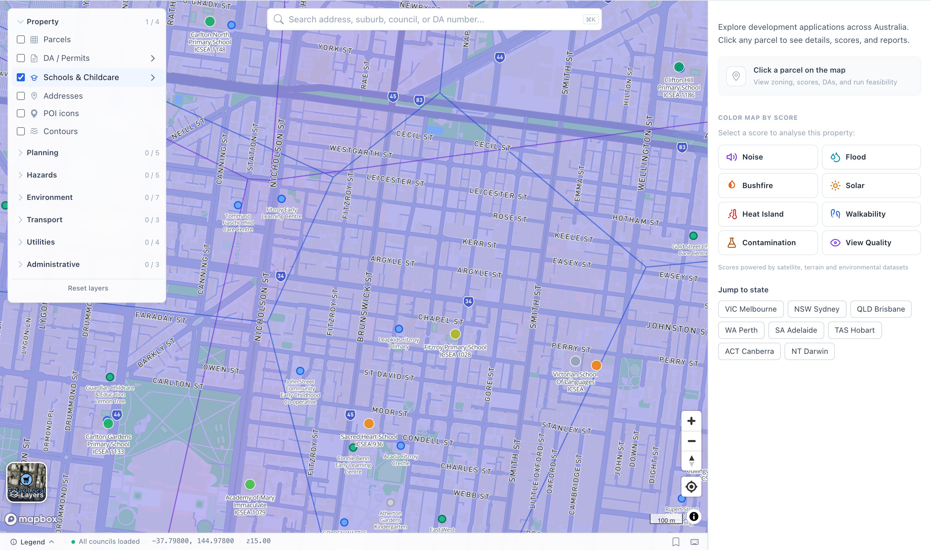
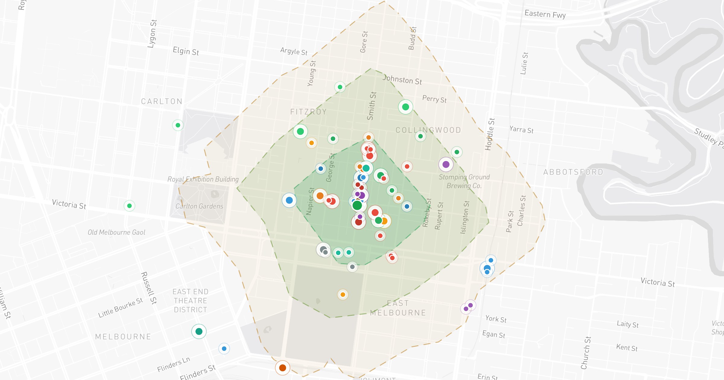
Destinations on our map: schools with catchment boundaries and childcare across Carlton and Fitzroy, the kind of amenity picture the score is built from.
An example from our walkability score page: a score of 76 reads as Very Walkable, meaning most daily needs sit within walking range. The bands run the way Walk Score users will expect: above 70 is very walkable, and 90+ approaches a walker's paradise where a car is optional for daily life. The map view draws 5, 10 and 15-minute walking ranges around the address, with the actual nearest amenity behind every category score, so you can see exactly which supermarket and which station the number is counting.
The honest limitation, stated plainly
Our distances are straight-line, not street-network routed. That is a real simplification and we would rather state it than dress the score up as routing it does not do.
Straight-line distance is a consistent, fast baseline that ranks addresses fairly against each other, and for most suburban addresses the difference is modest. Where it matters is exactly where you would guess: when a river, a railway line or an arterial road blocks the direct path, the real walk is longer than the crow flies, and the score will read generous. If an address you are serious about sits near one of those barriers, that is precisely when to fall back on Option 4 and let Google Maps route the actual streets. The slope penalty, at least, uses measured elevation, so hilly walks cost score even before routing enters the picture.
Which option should you use?
- Shortlisting suburbs or comparing 20 addresses: the modelled score. Free, instant, the same scale for every address, and it checks all 13 categories rather than the three you remembered to think about.
- Down to a handful of finalists: time-test your actual routine in Google Maps, especially if the score's map shows a river, railway or arterial between the address and its amenities.
- Final inspection: walk it yourself, at the gradient, in the weather, with the shopping bags in mind.
- Quick second opinion: Walk Score, which should broadly agree with ours; where the two diverge, that is worth a closer look, not a coin flip.
FAQ
What is a good walk score? On the 0-100 convention both Walk Score and our score use: 90+ approaches a walker's paradise, where a car is optional for daily life. Above 70 is very walkable, with most daily needs in comfortable walking range. Below that, expect to drive for at least some errands, and at the low end, for nearly all of them.
How is walkability measured? The standard approach, which ours follows, is destination-based: for each category of daily amenity, measure the distance to the nearest option, score it with distance decay so closer is better, weight categories by everyday importance, and sum to 0-100. Ours checks 13 categories within 1.5 kilometres and adds a terrain slope penalty from 30-metre elevation data.
Are the distances measured along streets? Ours are not; they are straight-line, and we state that openly. It matters most where a river, railway or arterial road blocks the direct path. For finalist addresses near a barrier like that, cross-check with routed walking directions in Google Maps.
Does the walkability score account for hills? Yes. Local slope from 30-metre elevation data penalises walks that are technically short but practically steep. A flat 800 metres and 800 metres up a stiff grade do not score the same.
Does walkability affect property value? The research points that way: walkable locations have commanded documented price premiums in many markets, and rental demand tends to track walkability too. How large the effect is varies a lot by city, property type and study, so we will not pretend there is one clean number. Direction, consistent; magnitude, it depends.
Is the walkability score free? Yes, for any address in Australia. Check an address on the map, or read the full methodology and its honest limitations on the walkability score page.