The weather forecast is for the whole city. Your street has its own climate.
Two addresses ten kilometres apart in the same metro can run measurably different temperatures on the same February afternoon, and the pattern is not random. Treeless new estates with dark roofs and full-lot coverage routinely measure hotter than leafy established suburbs in the same city. It is one of the most consistent patterns in satellite thermal data, and you cannot see it at a Saturday morning inspection.
It prices in, too. Academic studies estimate that urban heat costs roughly 0.8 to 1.5 percent of property value per extra degree, and unlike a dated kitchen, a hot microclimate is not something you renovate away. It means more cooling, higher summer bills, and harsher outdoor spaces for decades. So how do you actually check it before signing a contract?
The short version
| Visit in summer | Council / state heat maps | Canopy check on satellite view | Modelled score | |
|---|---|---|---|---|
| Cost | Free | Free | Free | Free |
| What you get | One afternoon's impression | A heat map, where one exists | A visual proxy for heat | 0-100 score from measured surface temperature |
| Covers | Wherever you stand, whenever you're there | Patchy: some LGAs and states only | Every address | Every address |
| Best for | Final gut check | Cross-checking, if your area is mapped | Quick street-vs-street comparison | Shortlisting + comparison |
The rest of this guide goes through each, plus a two-minute primer on how urban heat actually works so the numbers mean something.
First: how urban heat works, in two minutes
A few basics make every heat map and heat score easier to judge:
- An urban heat island is stored heat. Hard surfaces like roads, roofs, car parks and concrete absorb solar energy through the day and re-radiate it back out. A built-up area is effectively a battery of warmth that keeps discharging after the sun goes down, which is why the difference between a hard suburb and a green one is about the surfaces, not the weather.
- Land-surface temperature is not air temperature. Land-surface temperature (LST) is the temperature of the actual ground, roofs and roads. It is what thermal satellites measure, and it is the better predictor of how a street stores and radiates heat, because the surfaces are the heat island. It correlates with air temperature but is not identical to it: on a hot day a dark roof or a stretch of asphalt can run far hotter than the air above it.
- Tree canopy is the single biggest lever. Shade stops surfaces from charging up with heat in the first place, and vegetation moves water into the air instead of radiating warmth back out. This is why the satellite data keeps telling the same story: established canopy suburbs measurably out-cool new estates in the same city, and hard surface concentration versus tree cover is what separates neighbouring streets.
- You cannot inspect for it. A Saturday morning inspection tells you nothing about February afternoons. The heat difference between streets is real, measurable from orbit, and completely invisible at 10am in October.

What counts as "hot"?
There is no WHO guideline number for street heat the way there is for noise, so the honest approach is to anchor against how Australians actually live.
We ran a 350-point national sweep of residential land-surface temperatures to find out what Australian summers actually measure at the addresses people live at. The median residential summer surface temperature came out around 32.9°C. Our score bands are anchored against that distribution, so "Hot" means hot relative to real Australian residential land, not relative to an arbitrary threshold or a global average that includes Siberia.
Getting those bands right took iteration, and it is worth being honest about why. Our first band placement branded half the country "Hot", including leafy inner suburbs that are genuinely pleasant in summer. Widening the bands fixed the median but did the opposite damage: genuinely hot treeless estates started reading as "Cool". The current anchoring holds both ends, checked against a set of known-hot locations (treeless growth-corridor estates, large hardstand areas, Darwin) that all need to stay in the hot bands while the median Australian address lands in the middle. If a heat score cannot tell a new estate from a forested ridge, it is not measuring anything useful.
Option 1: Visit on a hot afternoon (free, rarely possible)
The ideal check is standing in the backyard at 4pm on a 38-degree February day. Feel the radiant heat off the driveway, see which rooms face the western sun, notice whether there is any shade to stand in.
The catch: buying timelines do not cooperate. If you are purchasing in June, the February afternoon does not exist for you, and even in summer you get one or two visits, which sample a couple of weather systems, not a climate. Heat exposure is a long-run property of the surfaces around an address, and one afternoon is an anecdote.
Option 2: Council and state urban heat maps (free, patchy)
Some councils and state governments publish urban heat island mapping for their areas, usually as part of climate adaptation or urban greening programs. Where one exists for your area, it is worth looking at: these maps are typically built from thermal imagery and show relative heat across a city or LGA.
The catch: coverage is patchy. Each map covers only its own council or region, they are published as one-off projects rather than maintained products, and if your address falls outside a published map there is simply nothing to check. There is no national urban heat map you can point at any address.
Option 3: Eyeball the tree canopy on satellite view (free, a proxy)
Here is a genuinely useful free trick: open any mapping site in satellite view and compare the streets you are considering. How much green canopy covers the street? Are the roofs dark or light? How much of each lot is hard surface?
Because canopy versus hard surface is the biggest driver of the heat difference between streets, your eyes on a satellite image are a rough but real heat proxy. A street where crowns touch across the road will run cooler than a street of dark roofs edge to edge, in the same suburb.
The catch: your eyes are not a thermometer. You can rank two streets roughly, but you cannot quantify the difference, compare across cities, or account for the regional climate baseline underneath. And it is slow across a shortlist of twenty addresses.
Option 4: A free modelled heat score (instant, every address)
This is what we built at DA Leads: a free heat island score for any address in Australia. Type an address, get a 0-100 score, where 100 is coolest, built from measured surface temperature rather than guesswork.
How it works, roughly
Three signal layers, in order of authority:
- Satellite surface temperature. NASA MODIS thermal imagery of summer land-surface temperature at 1km resolution, aggregated across multiple summers with a cloud-robust median. This is the measured heat of the actual surface around the address, not an estimate of it.
- Climate baseline. Five years of summer air temperature from ERA5 climate reanalysis provides the regional climate context, and acts as the fallback where satellite pixels are unusable.
- Local surface factors. Building density and greenspace around the address sharpen the picture, because hard surface concentration versus tree cover is what separates neighbouring streets inside a single satellite pixel.
Every response includes a source flag telling you whether the score came from satellite measurement or fell back to the climate baseline. If the number came from the fallback, you know you are looking at regional climate context rather than a measured local surface reading.
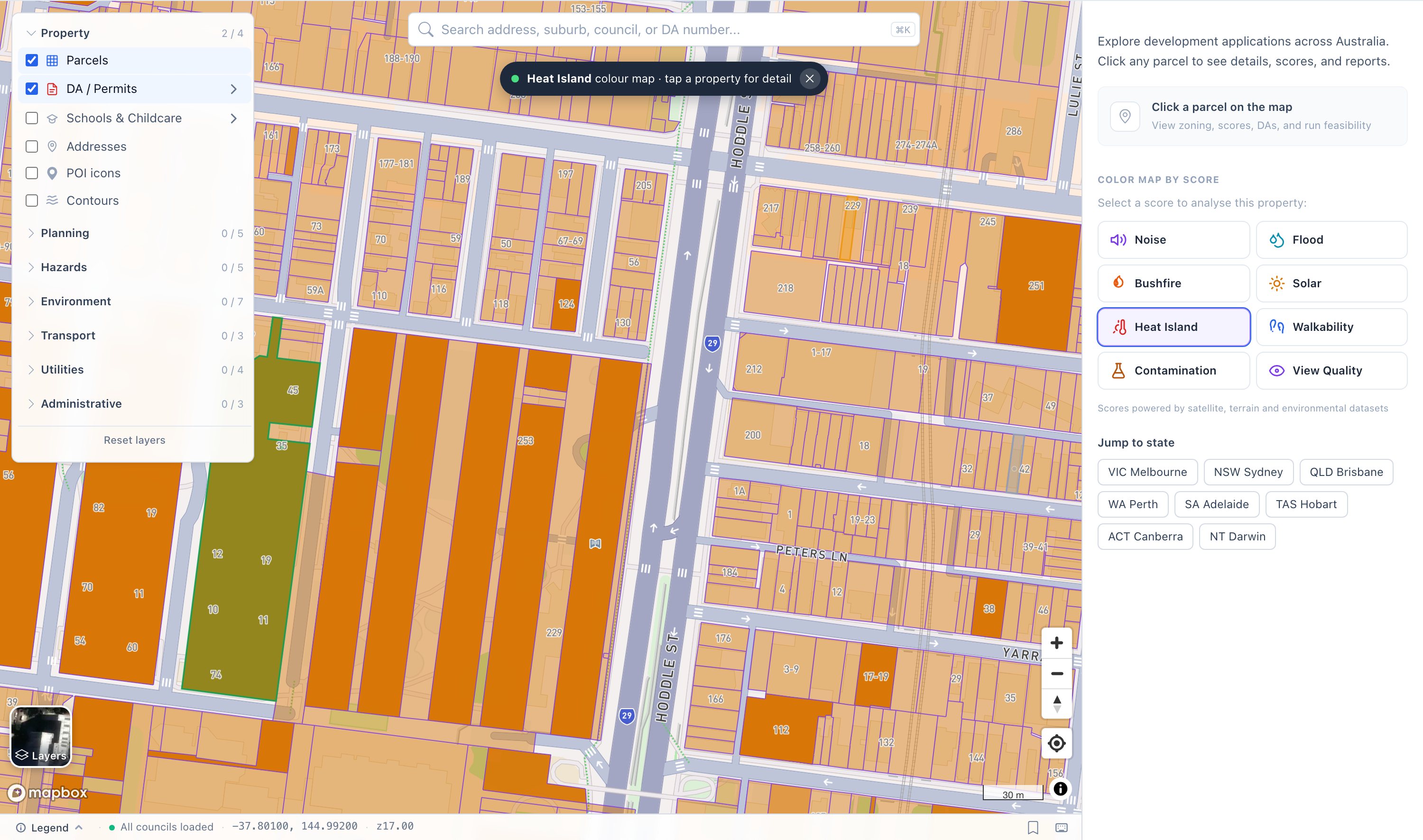
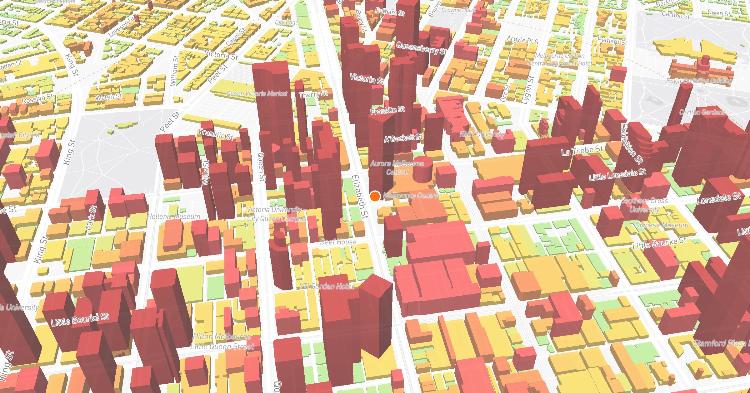
The heat island colour map on our map in Collingwood: hard hot streets in orange, the park-side block in green, street by street.
As a worked example: a score of 41 reads as "Moderate Heat", meaning summer surface temperatures near the metro median. Scores well below that indicate an address whose surfaces run genuinely hot relative to how Australians live, the treeless-estate pattern; scores well above it indicate the leafy, shaded end of the distribution.
What the number is not
Be clear about what you are reading:
- It is not air temperature. It is a score built on land-surface temperature, the heat of the ground, roofs and roads. That is deliberate, because the surfaces are what store and re-radiate heat, but it means the score will not match the number on your weather app.
- It is not a forecast. It is a climatology: how the surface environment around this address has measured across multiple recent summers. It tells you which streets run hot as a long-run property, not what next Tuesday will feel like.
- The satellite pixel is 1km. The measured surface temperature is a neighbourhood-scale reading, sharpened by the local density and greenery signals. Two houses on the same street will score similarly; that is the honest resolution of free national thermal data.
Which option should you use?
- Shortlisting suburbs or comparing 20 addresses: the modelled score, plus a quick canopy eyeball on satellite view for the finalists. Free, instant, same scale for every address in the country.
- Final inspection: if the calendar allows, visit late on a hot afternoon and pay attention to shade, roof colour and hard surfaces, informed by what the score says about how the street runs.
- If your council publishes a heat map: use it as a cross-check. Where a local map and the score disagree, walk the street on satellite view and trust the canopy.
FAQ
What is an urban heat island? A built-up area that runs hotter than its greener surroundings because hard surfaces like roads, roofs and car parks absorb solar energy and re-radiate it as heat. The effect is a property of the surfaces, which is why it varies street by street within the same city.
Is surface temperature the same as air temperature? No. Land-surface temperature is the temperature of the ground, roofs and roads themselves, which is what satellites measure. It correlates with air temperature but is not identical to it, and it is the better predictor of how a street stores and radiates heat, which is what a heat island is.
Why does my suburb run hotter than the one next door? Almost always surfaces: less tree canopy, darker roofs, more of each lot covered in hard material. Treeless new estates scoring hotter than established canopy suburbs in the same city is one of the most consistent patterns in the satellite data.
Do trees actually reduce heat? Yes, and they are the biggest lever available. Shade stops surfaces from absorbing solar energy in the first place, and vegetated ground stores far less heat than asphalt or dark roofing. It is why canopy cover is the clearest visible predictor of which streets run cool.
Does urban heat affect property value? Academic studies estimate roughly 0.8 to 1.5 percent of property value per extra degree of urban heat, alongside the direct running costs of cooling a hotter microclimate.
What does the DA Leads heat score measure? Summer land-surface temperature around the address from NASA MODIS satellite thermal imagery, aggregated across multiple summers with a cloud-robust median, combined with building density and greenspace, with ERA5 climate reanalysis as a fallback. It scores 0-100, where 100 is coolest, anchored against a 350-point national sweep of residential surface temperatures, and each response flags whether satellite or climate data produced it.
Check any address free on the map, or read the full methodology and honest limitations on the heat island score page.