
Battery storage site selection has a reputation for being a grid problem: find land near a transmission line with spare capacity and the rest is detail. The connection is the whole game commercially. That is exactly why planning constraints are what actually kill shortlisted sites: by the time a parcel makes a shortlist it is already near the grid, and so is every other parcel on the list. What separates them is fire separation, overlays, heritage and flood. Most of the fatal versions are visible from a desktop, before anyone commissions a study or signs an option agreement.
This guide walks through those constraints, then shows a real screen: a 20.4 ha parcel at Gregadoo in the Wagga Wagga LGA, run through our production engine. It did not come back a green light, and the reasons are more instructive than a clean report.
What actually kills BESS sites at the planning stage
Fire and hazard separation
Batteries fail differently from anything else on rural land: a cell in thermal runaway generates its own heat and gas, propagates to neighbours, and burns for a long time. So a BESS application carries a fire safety study, hazard separation to neighbours and boundaries, fire-authority-compliant emergency access, and dedicated firewater.
The standard usually waved around is AS/NZS 5139:2019 (Electrical installations - Safety of battery systems for use with power conversion equipment). Its formal scope covers systems from 1 kWh to 200 kWh, so a grid-scale BESS sits far outside it, though the standard notes its general requirements may inform larger installations. At grid scale the conversation runs through AS IEC 62933.5.2 and state fire authority guidance; our reports cite both.
Two site attributes decide how hard this fight is: distance to the nearest dwelling, and whether the site is in a mapped bushfire area. Our Gregadoo demo has both: nearest dwelling about 320 m, 49 dwellings inside 2,000 m (a noise assessment must consider all of them, not just the closest), and a mapped bushfire area over the site. The bushfire threatens the asset; the asset complicates the bushfire response. The screen rates this Moderate, not fatal, but it is the constraint most likely to eat design budget.
Planning overlays
Zoning rarely kills a rural BESS site; most candidate land is in a primary production zone broadly compatible with utility infrastructure. Overlays are where the money hides. The Gregadoo parcel returned two: a Vegetation Category 3 bushfire overlay (feeding the hazard picture above) and a Biodiversity vegetation overlay.
A biodiversity overlay reads like one line on a map and can cost a year. In NSW, if your clearing footprint pushes past the Biodiversity Offsets Scheme thresholds under the Biodiversity Conservation Act 2016, you need a Biodiversity Development Assessment Report prepared by an accredited assessor, which sets the number and class of biodiversity credits you must retire. Ecology surveys are seasonal, so a missed spring window can slide a DA by most of a year, and credits are a real line item that scales with what you clear.
The Gregadoo screen also shows why you read overlays against other evidence: NVIS extant vegetation mapping records the footprint itself as cleared, non-native vegetation, so the overlay likely captures adjacent land. That is the difference between "offsets sink this site" and "an ecologist needs a day here", and a desktop screen tells you which problem you have.
Aboriginal heritage
In NSW the register that matters is AHIMS, the Aboriginal Heritage Information Management System: the state's database of recorded Aboriginal sites, objects and declared Aboriginal Places under the National Parks and Wildlife Act 1974, access limited to registered users. It is not an open layer a screening engine can query, so an honest NSW desktop screen must return PENDING on Aboriginal heritage, and ours does.
What closes it is a due-diligence assessment under the NSW Due Diligence Code of Practice for the Protection of Aboriginal Objects: register searches, landscape assessment and, where indicated, site inspection. Following it gives a defence to the strict-liability offence of unknowingly harming Aboriginal objects; where impacts cannot be avoided, an Aboriginal Heritage Impact Permit is required. Budget for it early: it is cheap relative to a DA, and a late heritage find can stop earthworks entirely.
Flood
Batteries and inundation do not mix, and flood has the patchiest public data of the four. NSW flood mapping lives mostly in council flood studies of varying vintage, and on some sites, our Gregadoo demo included, no mapped layer covers the parcel at all. The honest desktop answer is another PENDING, resolved by the council flood study and 1% AEP level, not by assuming no mapping means no water.
A worked example: 20.4 ha at Gregadoo, Wagga Wagga
We ran our engine over a real parcel: Lot 61 DP757231 on Gregadoo East Road, 20.4 ha of RU1 Primary Production land south of Wagga Wagga. It is a demonstration on a real cadastral parcel, not a client project and not a proposal for that land, chosen because it is plausible: 252 m from a 330 kV line, near the Wagga 330 substation, where the national infrastructure dataset shows operational 330 kV lines to Darlington Point, Jindera and Lower Tumut plus a 500 kV Dinawan to Wagga Wagga line under construction.
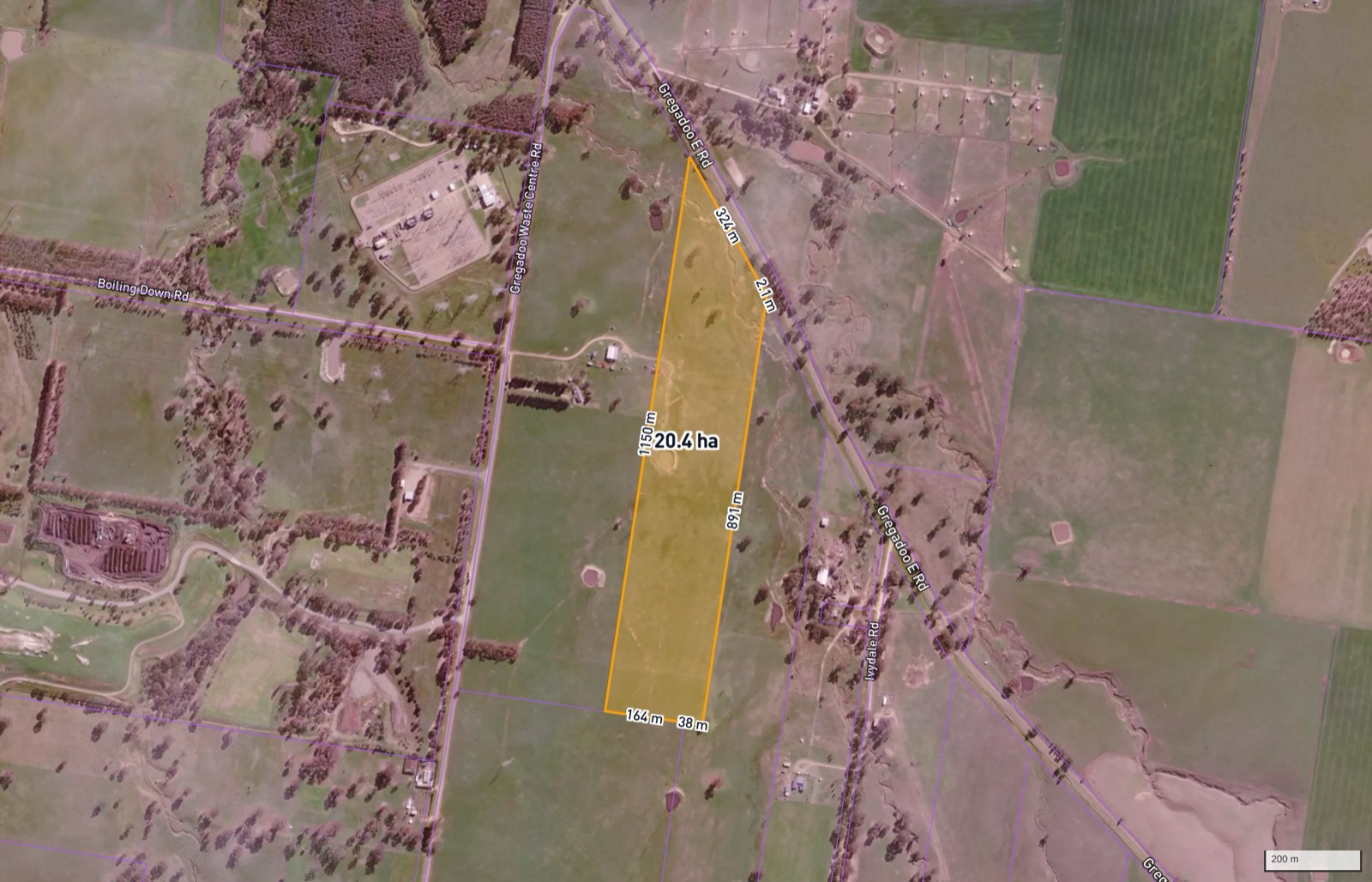 The demo parcel with an indicative footprint. All exhibits here come from the screening report our engine generated on this parcel as a demonstration.
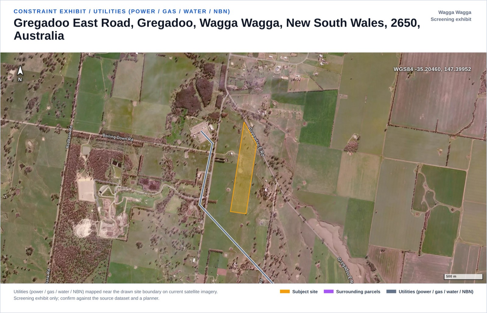 Why the parcel shortlists: a 330 kV line 252 m away.
The full 19-constraint result, exactly as the engine rated it:
| Constraint | Rating | Data status |
|---|---|---|
| Zoning | Insignificant | Assessed, clean (RU1 Primary Production) |
| Cadastral / Title & Easements | Minor | Data limited, title search required |
| Planning Overlays | Moderate | Two overlays mapped |
| Aboriginal Heritage | Pending | State register restricted, not desktop-assessable |
| Historic / Federal Heritage | Insignificant | Assessed, clean |
| Bushfire | Minor | Inside mapped bushfire area (Vegetation Category 3) |
| Flora & Fauna / Ecology | Minor | Overlay mapped; NVIS shows footprint cleared |
| EPBC / Matters of National Significance | Minor | Historical referral point nearby, PMST required |
| Hydrology / Flooding | Pending | Council flood mapping partial, no layer covers site |
| Noise (residential amenity) | Minor | Nearest dwelling about 320 m |
| Visual Amenity | Insignificant | Assessed, clean (low terrain visibility) |
| Contours / Topography | Insignificant | Mean slope about 1.8% |
| Geotechnical | Minor | Not desktop-assessable |
| Soils | Insignificant | Assessed, clean |
| Utilities (power / gas / water / NBN) | Minor | 330 kV line within 252 m |
| Traffic & Access | Minor | Data limited; TIA and OSOM route assessment required |
| Contaminated Land | Insignificant | Assessed, clean |
| Air Quality | Minor | Construction dust only |
| Hazard & Risk (fire / explosion) | Moderate | Thermal runaway profile, compounded by bushfire area |
The headline numbers: 17 of 19 constraints assessed, risk score 44/100, band "Workable with conditions", data completeness 89%, verdict "Indeterminate - key data missing". Zero Major, 2 Moderate, 9 Minor, 6 Insignificant, 2 Pending.
That verdict matters, because a 44 with no Major flags could easily be dressed up as a pass. It is not one. The two unassessed constraints, Aboriginal heritage and flood, are decision-critical for a battery, and the engine refuses to count unassessed as low risk, so the site cannot honestly be called a go until a heritage search and a flood study close those gaps. "Workable with conditions" describes what was assessed; "Indeterminate" describes the decision.
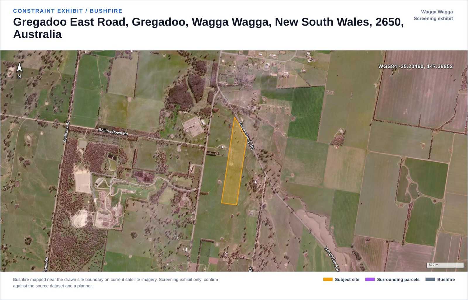 The bushfire exhibit: a mapped bushfire area over the parcel, compounding the battery's own fire load.
Where BESS applications are actually happening
Our development application database holds 848,471 council-lodged applications nationally. Filtering for battery energy storage returns 171, and the curve is steep: 5 lodgements in 2019, 41 in 2025, plus 16 in the first half of 2026 (partial year, excluded from the chart).
DA Leads database snapshot, queried 2026-07-12.
The state split looks strange until you understand what council data can see: SA 128, NSW 27, QLD 9, ACT 3, VIC 3, WA 1. SA is not hosting three quarters of Australia's battery development; two structural facts produce the skew. First, PlanSA is a single statewide portal that captures state-assessed applications alongside council ones; elsewhere we only see what individual councils publish. Second, utility-scale batteries in NSW and Victoria mostly never touch a council. In NSW, electricity generating works with a capital investment value above $30 million are State Significant Development under Schedule 1 of the State Environmental Planning Policy (Planning Systems) 2021, and the biggest go further: the Waratah Super Battery (around 850 MW / 1,680 MWh in our precedent data) was declared Critical State Significant Infrastructure and approved in February 2023. In Victoria the Minister for Planning decides permit applications for energy generation facilities of 1 MW or more. SA's big batteries also run a state route: the Templers BESS (about 111 MW / 330 MWh, energised 2025) went through as essential infrastructure under the PDI Act 2016.
Council DA data is therefore a lens on the small-to-mid end (distribution-scale batteries, storage added to existing solar farms, commercial installations), which is where council-by-council intelligence pays off. The busiest NSW council for BESS applications in our data is Port Stephens with 7; you can browse any LGA, including Wagga Wagga, or take the state view for NSW and SA.
A screening checklist where every verb has a tool
A checklist is only useful if each line says where the answer lives:
| Check | How to actually check it |
|---|---|
| Zoning and overlays | State planning map portal, or any address on our free map (zoning, overlays, parcels) |
| Grid proximity | Geoscience Australia's Foundation Electricity Infrastructure dataset (the layer our engine uses) |
| Nearest dwellings | Address points (we use G-NAF); count receptors within 2 km, not just the closest |
| Bushfire mapping | The relevant state's bushfire prone land map |
| Aboriginal heritage (NSW) | Register with AHIMS and run a basic search; not in open spatial data |
| Federal environment (EPBC) | Generate a Protected Matters Search Tool (PMST) report, then self-assess against the nine MNES |
| Flood | Council flood study and 1% AEP level; if unmapped, ask the council, do not assume clear |
| Title and easements | Certificate of Title from the state land registry (about A$30, about a week) |
| All 19 at once | Our energy site screening memo: 19 constraints on any parcel, one business day |
What a desktop screen cannot close
Every line above that says "pending" or "data limited" stays that way until someone spends money offline. A desktop screen cannot read a registered title, search AHIMS, or drill: easements wait on the title order, heritage on a register search and usually a due-diligence assessment, geotech on boreholes. A formal PMST report and ecology survey belong to consultants.
What a screen does is sequence the spend. On the Gregadoo example it turns "20 ha near a 330 kV line" into an ordered list: title order in week one, heritage search and flood study before any option fee, ecologist to confirm the cleared footprint, fire safety scoping alongside concept design. That ordering is the entire value of a screen.
FAQ
What kills most BESS sites at the planning stage in Australia? Fire and hazard separation (distance to dwellings, compounded by mapped bushfire areas), biodiversity overlays that trigger offsets and seasonal surveys, Aboriginal heritage findings, and flood exposure. Grid distance filters the shortlist first; among grid-close parcels these planning constraints decide the winner.
Is a BESS site inside a bushfire zone a deal-breaker? Not automatically. Our Gregadoo demo screen sits in a mapped Vegetation Category 3 bushfire area and still rated "Workable with conditions" at 44/100. It makes the fire workstream heavier: bushfire hazard assessment, asset protection zones, emergency access and firewater, on top of the battery's own fire safety study.
Why can't a desktop screen assess Aboriginal heritage in NSW? Because AHIMS, the NSW register of recorded Aboriginal sites and objects, is restricted to registered users, not published as an open spatial layer. An honest screen returns PENDING and points you to an AHIMS search and a due-diligence assessment. Any desktop product showing NSW heritage as "clear" has assumed, not checked.
Do battery projects go through local councils? The big ones mostly do not. In NSW, electricity generating works above a $30 million capital investment value are State Significant Development; in Victoria the Minister for Planning decides energy generation facilities of 1 MW or more. Council registers mainly capture distribution-scale and commercial batteries, which is why our 171 council-lodged BESS applications skew to SA, where the statewide PlanSA portal also captures state-assessed applications.
What does an "Indeterminate" verdict on a screening report mean? It means decision-critical constraints could not be assessed from available data, so the report refuses to call the site a go. On the Gregadoo example none of the 17 assessed constraints was Major, but Aboriginal heritage and flood were pending, so the verdict stays "Indeterminate - key data missing" until those checks close.


