
Search for data centre land requirements and you get the same checklist everywhere: power, fibre, water, flat land in an industrial zone. All true, and all useless when you are staring at an actual parcel. The generic list never says which requirements you can settle from your desk this week, which ones only a network operator can answer, or what the grassland reserve over the back fence does to your approvals program.
This guide is grounded differently. In July 2026 we ran four real cadastral parcels in Melbourne's west through our 19-constraint screening engine while choosing a demonstration site. Three failed, each for a different reason. The fourth, a 24.7 ha industrial parcel in Laverton North, passed with a risk score of 44/100 ("Workable with conditions", no fatal flaws, four moderates) and became our public sample report. Every requirement below is anchored in what that screen found. None of the parcels is a client project or a proposal for that land; they are real examples run to demonstrate the screen.
Two lists: what spatial data answers, and what it cannot
The requirements split into two buckets, settled by different kinds of work.
| Answerable from public spatial data, today | Not answerable from any map |
|---|---|
| Zoning and planning overlays | Grid hosting capacity at a connection point |
| Mapped easements and corridors crossing the site | Fibre routes and available capacity |
| Ecology: reserves, threatened communities, native vegetation | Water and sewer supply agreements |
| Cultural heritage sensitivity mapping | |
| Flood and bushfire mapping | |
| Distance to dwellings and residential zones | |
| Distance to transmission, substations, gas and water mains |
The left column is a desktop exercise; our screen resolves it in a business day. The right column is meetings, and to be plain: we hold no grid hosting-capacity data and no fibre-route data. Any provider telling you a spatial layer answers those questions is overselling. What a map can honestly do is measure distance to the mapped network: which conversation to start, and with whom.
Zoning: what data centres actually get built on
Data centres get built on industrial land. Our demo parcel is zoned IN2Z, Industrial 2, under the Wyndham planning scheme, and the engine rated zoning insignificant: compatible with the use. That is what a good zoning result looks like: boring.
In NSW, "data centre" has been a defined land use term since 2021, characterised as a type of high-technology industry. The zones to look for are E4 General Industrial and E5 Heavy Industrial, the standardised employment zones created in the December 2021 reform that replaced the old business and industrial zones in local plans from April 2023.
The trap is that a metropolitan industrial belt is not uniformly industrial. Melbourne's west looks like one continuous estate on satellite, but of our four screened parcels, one was UGZ2 (Urban Growth Zone: the residential growth front, 8,641 dwellings already within 2 km) and one was PCRZ (Public Conservation and Resource Zone), flagged major because the use may be prohibited outright. The map said industrial estate; the zone said conservation reserve. The full four-parcel story is in our screening guide.
Zoning also does not fix your consent authority. In NSW, a data centre above 15 MW total power consumption is State Significant Development, assessed by the state rather than council (raised from 10 MW on 1 June 2023). In Victoria, the Development Facilitation Program gives data centres costing at least $20 million in metropolitan Melbourne an expedited ministerial pathway; a West Footscray data centre (PA2403320) was approved that way in April 2025.
Size and shape: what the hectares are for
Our demo parcel is 24.7 ha. The report draws an indicative building footprint of roughly 3 ha at its centre: a presentation-only marker the engine renders so separation distances are legible, not a design. The other twenty-odd hectares buy everything else a design needs: substation and switchyard space, generator yards and fuel storage with their own separations, the sterilised strip along the easement that crosses the site (more below), and room to keep noisy plant away from the boundary.
At the campus end, the precedent in our report is NEXTDC's S4 at Horsley Park in western Sydney: six buildings and about 250 MW, approved as SSD on 24 December 2025. We are deliberately not publishing a hectares-per-megawatt ratio: power density varies so much between designs that any such number would be an invention.
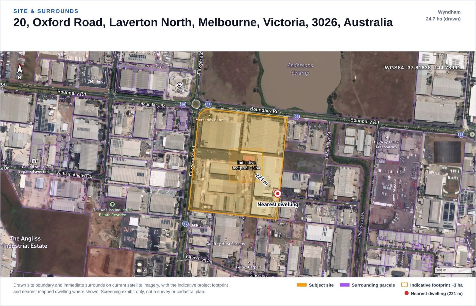 Site exhibit from the screening report our engine generated on a real Laverton North parcel as a demonstration (not a client project, not a proposal for that land): the 24.7 ha boundary, indicative ~3 ha footprint, and nearest dwelling at 221 m.
Power adjacency, honestly
The most repeated requirement is "near power". Here is what that looked like on a real screen: a 66 kV line crosses our demo parcel, logged by the utilities check as within 1 m: engine shorthand for a line through the site.
That fact reads two ways, and both are true. On the supply side it is convenient: the network is literally on the land. On the cadastral side it is one of the four moderates: "1 infrastructure corridor(s) / easement(s) cross the site; these carry registered easements and setbacks that constrain where plant can be built." An easement sterilises a strip of your parcel, and its width and terms live on the Certificate of Title, not in any spatial layer, so the screen's next step is a title order.
Voltage class matters as much as distance. A 66 kV line is sub-transmission: it feeds zone substations, and it does not power a hyperscale campus of the S4 class. Whether any line, at any voltage, can serve your load is a hosting-capacity question, and that is a network-operator conversation, full stop. What the spatial layer (Geoscience Australia's Foundation Electricity Infrastructure dataset, in our case) legitimately gives you is distance and voltage class, so you can rank candidates and approach the right operator. How to read those layers, and how not to, is in our transmission proximity guide.
The constraints nobody prices in
Everything here came from the screen of the parcel that passed: items that lengthen an approvals program and never appear on the generic checklist.
Ecology, 39 m away. Derrimut Grassland Nature Conservation Reserve sits 39 m from the boundary. The volcanic-plain grassland of Melbourne's west drove two of the four moderates at once: flora and fauna (mapped threatened biota of the Western Victorian volcanic plain intersects the site) and EPBC, because a Matter of National Environmental Significance is likely triggered and a referral is required. That pairing is normal here, and it means ecologist surveys and a Commonwealth workstream on land the zoning map calls plain industrial.
Receptor separation, which distance alone does not clear. The nearest dwelling is about 221 m away, with 1,007 dwellings within 2 km. A comfortable margin for many industrial uses, but cooling plant runs 24 hours a day, so the engine treats a data centre as a high-acoustic-output class and rates noise moderate regardless: an assessment against the state noise policy is required, covering all receptors in the affected area, not only the closest. The cover image of this article is that receptor exhibit.
Standby diesel makes you a dangerous goods site. A data centre has no continuous combustion, but standby generation means bulk diesel storage, a dangerous good stored and handled under AS 1940:2017 (flammable and combustible liquids). Per the screen: quantities are typically below Major Hazard Facility thresholds but must be confirmed against dangerous-goods notification thresholds, generator testing produces intermittent emissions with EPA licensing depending on installed capacity, and UPS battery rooms carry their own fire-safety standards. Real line items, priced by almost nobody at land selection.
Water within 23 m is not a water supply. The screen found a water and sewer main within 23 m. Genuinely useful adjacency, and the exact boundary of what a map can say: supply agreements, capacity and headworks charges are a utility conversation. Better to say that than imply a blue line on an exhibit solves your cooling make-up water.
Heritage can add a statutory workstream before you lodge. In Victoria, cultural heritage sensitivity mapping is a statutory trigger: where a high impact activity is proposed within a mapped area of cultural heritage sensitivity, a Cultural Heritage Management Plan must be prepared and approved before permits can be issued, under the Aboriginal Heritage Regulations 2018. Not hypothetical: the first parcel in our story sat inside a mapped sensitivity area, and that finding (with a dwelling at about 121 m) failed it. The demo site is outside the mapped area; protection still applies, so an unexpected-finds procedure applies during works.
The checklist, with the tool that answers each row
| Requirement | What actually answers it |
|---|---|
| Zoning, overlays, permissibility | State planning portal, or our free map for any address |
| Easements crossing the site | Mapped corridors in our screening memo; Certificate of Title for terms |
| Distance to transmission and substations | Geoscience Australia Foundation Electricity Infrastructure data (our screen's layer) |
| Grid hosting capacity | Network operator connection enquiry. No map answers this |
| Fibre routes and capacity | Carrier enquiry. No public spatial layer answers this |
| Ecology and EPBC exposure | Screening memo, then PMST report and ecologist survey |
| Cultural heritage sensitivity | State mapping (in the screen); CHMP by a heritage advisor if triggered |
| Receptor separation and noise | GNAF dwelling points in the screen; acoustic consultant for the assessment |
| Flood and bushfire | State hazard mapping, resolved in the screening memo |
| Diesel storage compliance | AS 1940:2017 design plus dangerous-goods notification |
| Water/sewer adjacency | Mapped mains in the screen |
| Water supply agreement | Utility enquiry. Not a map layer |
Honest limits, and what a screen is for
A desktop screen is the start of diligence, not the end. Ours rates 19 constraints against live state and national layers and flags what it cannot see rather than assuming it clear: on the demo report, geotechnical and traffic are marked not desktop-assessable, the EPBC rating comes from mapped matters rather than a Protected Matters Search, and vector data is generalised, not survey accurate. It is not planning advice and does not replace your consultants; it tells you, for A$1,000 per site in one business day, whether a parcel deserves their fees.
If you are screening candidate land, read the full sample report on the Laverton North parcel, or start with the data centre site screening service. The free map shows zoning, overlays and parcels for any address, and developers building their own tools can hit the property API sample.
FAQ
What zoning does a data centre need in Australia? Industrial zoning is the practical answer: our Victorian demo parcel is IN2Z (Industrial 2), and in NSW the equivalents are the E4 General Industrial and E5 Heavy Industrial employment zones. Confirm permissibility in the specific scheme, because industrial belts interleave growth-zone and conservation land with genuine industrial parcels.
How much land does a data centre need? There is no honest universal ratio; power density varies too much between designs. Our demo screen used a 24.7 ha parcel with an indicative 3 ha footprint drawn for presentation, while campus projects like NEXTDC S4 run to six buildings and about 250 MW. The land beyond the halls goes to substations, generator yards, fuel separations, easement setbacks and noise buffers.
Does being next to a transmission line mean I can connect? No. Proximity and voltage class tell you which network operator to approach; whether the network can host your load is a connection enquiry only that operator can answer. On our demo parcel the crossing 66 kV line was simultaneously convenient and a moderate constraint, because its easement sterilises a strip of the site.
Do data centres need a noise assessment even with no close neighbours? In practice, yes. Cooling plant runs 24/7, so screening treats a data centre as a high-acoustic-output use: our demo report rates noise moderate at a 221 m nearest dwelling and requires an assessment covering every receptor in the area.
What approvals pathway applies to a data centre? In NSW, above 15 MW total power consumption it is State Significant Development. In Victoria, metropolitan projects costing at least $20 million can use the ministerial Development Facilitation Program. Below those thresholds you are generally with council.


