
Every industrial land checklist reads the same way: zoned industrial, flat, serviced, close to the freeway network. All true, and all of it visible from a satellite photo. The constraints that actually shape an industrial project sit under that surface: what the title says about the corridor crossing the lot, what the grassland reserve up the road does to your approvals program, whether the address point 109 m from the boundary is a dwelling or a factory unit.
In July 2026 we ran a 2.9 ha infill lot in the Fitzgerald Road area of Laverton North, in Melbourne's west, through our 19-constraint screening engine as a public demonstration. The parcel is real; it is not a client project, and nothing is proposed for that land. On the generic checklist it is close to perfect: zoned IN2Z (Industrial 2) under the Wyndham planning scheme, a 1.4% grade, power, gas and water all mapped within 50 m. The screen still returned five moderate constraints and a risk score of 50/100, in our "Heavily constrained" band. Nothing fatal. But the distance between "ticks every box" and "heavily constrained" is exactly the layer this article is about.
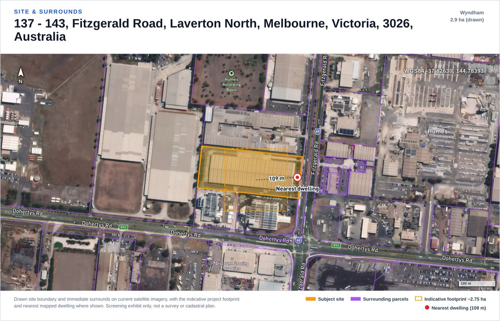 Site exhibit from the screening report our engine generated on a real 2.9 ha Laverton North parcel as a demonstration (not a client project, not a proposal for that land).
Two lists: what a desktop answers, and what it cannot
Industrial land due diligence divides into questions public spatial data can settle this week and questions no map answers, and a screen that blurs the two is selling comfort, not information.
| Answerable from public spatial data, today | Not answerable from any map |
|---|---|
| The zone the lot is actually in, and any overlays | Road network capacity and intersection performance |
| Mapped corridors and easements crossing the lot | Easement terms: width, beneficiary, what you may build over it |
| Reserves, threatened communities, native vegetation | Whether your goods profile triggers dangerous goods licensing |
| Address points and residential zones, as distances | Whether a given address point is an occupied dwelling |
| Distance to power lines, gas pipelines and water mains | Network capacity and connection terms |
| Flood and bushfire mapping, contamination registers, slope | Ground conditions under the slab |
Zoning that lies to the satellite
Start with the question everyone assumes is settled: is the land industrial at all? While selecting the demo lot we probed parcels across the same western Melbourne belt, and the zone query kept contradicting the aerial photo. Two Ravenhall parcels that read as ordinary industrial estate from the air returned Special Use zones (SUZ1 and SUZ8). Another Laverton North parcel returned PCRZ, the Public Conservation and Resource Zone. We have not verified what those Special Use schedules allow; the point stands without it: three probes, the landscape said industrial, the planning scheme said otherwise.
The demo lot is what a clean result looks like: IN2Z, rated insignificant, no planning overlays intersecting the boundary. Boring, which is the goal. The rule: zone first, before you inspect, before you model rent, before you brief anyone. It is free on our map for any address.
Easements and corridors: convenient and encumbered at once
The demo lot has an infrastructure corridor crossing it, and the cadastral check rated that moderate: crossing corridors carry registered easements and setbacks that constrain where a building can go on the 2.9 ha. Meanwhile the utilities check, reading the same neighbourhood, rated insignificant: a 66 kV line within 50 m, a gas transmission pipeline within 24 m, a water or sewer main within 30 m. Not a contradiction. Convenient services and title constraints are the same infrastructure read from two directions, and industrial estates do this constantly.
No spatial layer can give you the terms: the easement's width, its beneficiary, and what you may build or pave over it live on the Certificate of Title, about a week to order. The screen's job is to force that order to the top of the program, before a layout is drawn around a strip you may not be allowed to rack. How to read mapped power infrastructure honestly is covered in our transmission line proximity guide.
Grassland under the industrial belt
Melbourne's west is volcanic plain, and remnants of its native grassland survive between the warehouses. Angliss Grassland (Laverton North) Nature Conservation Reserve sits about 478 m from the demo lot, and mapped threatened biota, which the engine names as the Southern Plains including the Western Victorian volcanic plain and karst springs, intersects the site itself. That one ecological context drove two of the five moderates: flora and fauna, and EPBC, where a Matter of National Environmental Significance is likely triggered and a referral is required.
Industrial zoning gives no exemption here. An EPBC referral asks the Commonwealth Environment Minister to decide whether the action needs assessment and approval under the EPBC Act, and the trigger is likely significant impact on a protected matter, not what the land is zoned. The consequence is surveys, and surveys have seasons. A desktop flag becomes a flora and fauna survey by a qualified ecologist plus a Protected Matters Search Tool report, and grassland flora surveys must be timed to when the indicator species are detectable. Miss the window and the program waits for the next one, on land the zoning map calls plain industrial.
The receptor question, read honestly
The nearest GNAF address point sits about 109 m from the demo lot, one of 1,130 address points within 2 km. A screen that stops reading there calls major and moves on. But that nearest point is a unit address inside the neighbouring industrial complex, and the nearest mapped residential zone is about 5 km away. The engine's proxy-confirmation logic capped the rating at moderate, not major, and attached verbatim: "The nearest point is a GNAF address point that may be non-residential (the nearest mapped residential zone is about 5000m away); confirm whether it is an occupied dwelling before relying on this rating." The cover image of this article is that receptor exhibit.
The cap does not make noise go away: a noise assessment must still consider all receptors in the affected area, not only the closest point.
The freight task is the assessment, not a footnote
For a warehouse, traffic is not a construction-phase nuisance. The engine applies a project-type rule and rates Traffic and Access moderate on principle: "Freight / logistics use: operational heavy-vehicle traffic is intrinsic and a Traffic Impact Assessment with intersection modelling is required." Dock cycles, line-haul and last-mile trips run across extended hours, access design needs swept paths and, where sought, approved B-double routes, with construction traffic on top during the build.
The screen is explicit about its boundary: we hold no traffic count data, no AADT, so the data status stays data-limited rather than pretending a desktop measured the road network. What it does is put the TIA on the program as a primary assessment matter rather than a late line item.
What the shed stores decides the hazard
The hazard and risk check carries the most honest sentence in the report: a warehouse's on-site hazard is set by what it stores, which is not knowable from a desktop. General freight carries no significant fire or explosion hazard. Dangerous goods storage triggers licensing, separation and placarding requirements under state dangerous goods legislation. In Victoria, where the demo lot sits, an occupier must notify WorkSafe Victoria once dangerous goods on the premises exceed the quantities in Schedule 2 of the Dangerous Goods (Storage and Handling) Regulations 2022. Where the goods are flammable or combustible liquids, storage and handling is designed to AS 1940:2017, the Australian Standard for those liquids.
None of that is visible in any spatial layer, so the honest desktop output is a minor rating with one required check: confirm the intended goods classes against the state thresholds before the design settles, because the answer changes the building.
The full 19 rows
The complete table from the demo screen, as the engine recorded it.
| # | Constraint | Rating | Data status |
|---|---|---|---|
| 1 | Zoning | Insignificant | Assessed, clean |
| 2 | Cadastral / Title & Easements | Moderate | Assessed, finding |
| 3 | Planning Overlays | Insignificant | Assessed, clean |
| 4 | Aboriginal Heritage | Minor | Assessed, finding |
| 5 | Historic / Federal Heritage | Insignificant | Assessed, clean |
| 6 | Bushfire | Insignificant | Assessed, clean |
| 7 | Flora & Fauna / Ecology | Moderate | Assessed, finding |
| 8 | EPBC / Matters of National Significance | Moderate | Assessed, finding |
| 9 | Hydrology / Flooding | Insignificant | Assessed, clean |
| 10 | Noise (residential amenity) | Moderate | Assessed, finding |
| 11 | Visual Amenity | Minor | Assessed, finding |
| 12 | Contours / Topography | Insignificant | Assessed, clean |
| 13 | Geotechnical | Minor | Data limited |
| 14 | Soils | Insignificant | Assessed, clean |
| 15 | Utilities (power / gas / water / NBN) | Insignificant | Assessed, finding |
| 16 | Traffic & Access | Moderate | Data limited |
| 17 | Contaminated Land | Insignificant | Assessed, clean |
| 18 | Air Quality | Minor | Assessed, finding |
| 19 | Hazard & Risk (fire / explosion) | Minor | Assessed, finding |
The verdict: "No fatal flaws identified", with 0 major, 5 moderate, 5 minor, 9 insignificant, 0 pending, all 19 assessed at 100% data completeness, risk score 50/100, band "Heavily constrained".
Read those two lines together. "Heavily constrained" does not mean broken; there is no fatal flaw on this lot. It means five scoped workstreams before anything is lodged: the title order for easement terms, the ecology survey, the EPBC referral pathway, the noise assessment with receptor confirmation, and the Traffic Impact Assessment with intersection modelling. A generic checklist would have scored this parcel near-perfect and met those five one at a time, weeks deep into design. The screen delivers all five on day one, priced and ordered.
Honest limits, and where a screen fits
A desktop screen is the start of diligence, not the end. Two constraints here are data-limited: geotechnical conditions are not desktop-assessable, and traffic was not measured because we hold no count data. The EPBC rating comes from referral proximity and mapped matters rather than a Protected Matters Search run. Mapped vectors are generalised at zoom, not survey accurate. The screen is not planning advice and does not replace your planner, ecologist, acoustic consultant or traffic engineer; it tells you, for A$1,000 per site in one business day across 19 constraints, whether a parcel deserves their fees and what to brief them on.
If you are weighing industrial land, read the full sample report, then the warehouse site screening service. The step-by-step method is in our warehouse site screening guide. The free map shows zoning, overlays and parcels for any address, and developers can pull the same data from the API sample.
FAQ
What should industrial land due diligence cover beyond zoning and services? The constraint layer under the checklist: easements and corridors, ecology and EPBC exposure, receptor status rather than raw address points, the operational freight task, and whether the goods profile triggers dangerous goods licensing. On our 2.9 ha demo screen, five of those became moderate constraints on a lot that passes every generic test.
Can land look industrial on satellite but have a different zone? Yes, three times in one site-selection exercise. Two Ravenhall parcels that read as industrial estate from the air returned Special Use zones (SUZ1 and SUZ8), and a Laverton North parcel returned PCRZ, a conservation zoning. Query the zone first; it is free on our map for any address.
Do easements matter if the services are convenient? They are two readings of the same infrastructure. The demo lot has a 66 kV line within 50 m and a gas pipeline within 24 m, excellent adjacency, and a corridor crossing the lot, a moderate title constraint. The easement's width and terms are on the Certificate of Title, not on any map.
Why would a warehouse lot inside an industrial estate get a noise constraint? Because the nearest mapped address point was about 109 m away. Our engine identified it as a unit address inside the neighbouring industrial complex rather than a confirmed dwelling, capped the rating at moderate instead of calling a false major, and flagged it for confirmation.
Does industrial zoning exempt a project from EPBC referral? No. EPBC turns on whether the action is likely to significantly impact a Matter of National Environmental Significance, regardless of zoning. The demo lot sits about 478 m from a grassland conservation reserve with mapped threatened biota intersecting the site, so the screen rates a referral likely required despite the industrial zone.
What does a "Heavily constrained" risk band actually mean? On the demo report it means a risk score of 50/100 with no fatal flaws: nothing precludes development, but five moderate constraints each demand a scoped workstream (title, ecology, EPBC, noise, traffic) before a development application is ready. It is a program and budget signal, not a verdict against the site.


