
Data centre site selection in Australia usually starts with a spreadsheet of substations and fibre routes. Power first, connectivity second, land third, planning last, a "DA risk" line item to be looked at once the deal is nearly agreed.
That order is backwards. This month, while selecting the demonstration site for our data centre screening service, we ran four real cadastral parcels in Melbourne's west through our production engine's 19-constraint planning screen. Three failed, each for a different reason, and every reason was checkable from a desktop on day one, before anyone commissioned a connection enquiry or priced a fibre build.
Four parcels, one survivor
All four are real parcels with real cadastral identifiers, screened as demonstrations while we built the service; none is a client project or a proposal for that land.
| # | Parcel | Size and zone | What the screen found | Outcome |
|---|---|---|---|---|
| 1 | Truganina (parcel PC378285) | 7.9 ha | Nearest dwelling about 121 m; 1,790 dwellings within 2 km; inside a mapped Area of Cultural Heritage Sensitivity | Failed |
| 2 | Truganina, The Crossing (Lot 6 PS803442) | 10.5 ha, UGZ2 | Nearest dwelling about 125 m; 8,641 dwellings within 2 km; ecology and EPBC moderates; risk score 61/100 | Failed |
| 3 | Laverton North (Lot 2003 PP3651) | 16.4 ha, PCRZ | Zoning rated Major: conservation zone, use may be prohibited | Failed |
| 4 | Laverton North (Lot 1 TP712726) | 24.7 ha, IN2Z | No fatal flaws; 4 moderates; risk score 44/100 | Survived |
Parcel 1: the doorstep problem, plus a heritage workstream
A 7.9 ha parcel in Truganina, reading on satellite as a maturing industrial neighbourhood. Two findings struck it out. First, residential encroachment: the nearest dwelling about 121 m away, with 1,790 dwellings within 2 km. A data centre's cooling plant runs 24 hours a day, so 121 m is uncomfortably close before you have drawn a single building.
Second, the parcel is inside a mapped Area of Cultural Heritage Sensitivity. The engine's exact wording: "Within a mapped Area of Cultural Heritage Sensitivity; a Cultural Heritage Management Plan is likely required." In Victoria that mapping carries statutory weight (more below); our fee schedules carry an indicative A$10K to A$40K for the CHMP workstream. Two findings, visible in minutes, that no power and fibre analysis would surface.
Parcel 2: the growth front wearing an industrial costume
A 10.5 ha parcel at The Crossing, Truganina, zoned UGZ2, Urban Growth Zone Schedule 2. UGZ is the zone Melbourne applies to its expansion fronts, and the receptor numbers say what that means: 8,641 dwellings within 2 km, the nearest about 125 m. Not an industrial precinct with houses at the edge; a housing estate in mid-delivery, getting worse for an industrial use every year.
The ecology findings are the instructive part. Flora and fauna came back moderate for threatened biota ("Southern Plains including the Western Victorian volcanic plain and karst springs"), and EPBC moderate too: a Matter of National Environmental Significance likely triggered, referral required. Melbourne's western growth corridor was built across volcanic plain grassland, and remnants sit under the development front. The parcel got a full 19/19 assessment and scored 61/100 against the eventual survivor's 44. In short: a 24/7 industrial facility in the middle of the residential growth front, with national-significance grassland questions attached.
Parcel 3: the satellite lied
A 16.4 ha parcel in Laverton North that looks, on imagery, like the rest of the industrial estate around it: flat, open, cleared. The zone query said otherwise. It returned PCRZ, the Public Conservation and Resource Zone, and the screen rated zoning as Major: "Site is within a sensitive zone (PCRZ); use may be prohibited or strongly discouraged."
It is a conservation reserve. The satellite said industrial estate; the zone said protected land. Zoning is the one constraint where a single attribute kills a site outright, and it is the cheapest thing on the checklist to look up.
Parcel 4: the survivor, with four moderates worth understanding
A 24.7 ha parcel in Laverton North (Lot 1 TP712726), zoned IN2Z, Industrial 2 Zone. The screen assessed 19/19 constraints at 100% data completeness and returned "No fatal flaws identified": 0 major, 4 moderate, 6 minor, 9 insignificant, 0 pending, risk 44/100, "Workable with conditions". This is the site behind our live sample report.
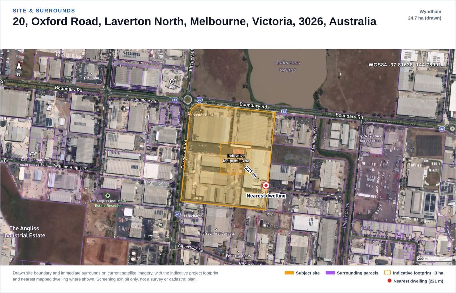
Site and surrounds exhibit from the screening report our engine generated on this real Laverton North parcel as a demonstration (not a client project or a proposal for that land): 24.7 ha boundary, indicative ~3 ha footprint, nearest dwelling at 221 m.
"Workable with conditions" is doing real work there. The four moderates are scoped, costed workstreams rather than dealbreakers, and each is typical of Melbourne's west:
- An easement crosses the site. A 66 kV transmission line crosses the parcel; in the engine's words, such corridors "carry registered easements and setbacks that constrain where plant can be built". That dictates where halls, generator yards and fuel storage can go, so the Certificate of Title comes first. (We cover how national transmission proximity data works in our transmission line guide.)
- Derrimut Grassland Nature Conservation Reserve is 39 m from the site. Threatened biota and native vegetation are mapped on and around the parcel, so a flora and fauna survey and a native vegetation clearance assessment are on the critical path.
- EPBC. A Matter of National Environmental Significance is likely triggered, referral required: the Victorian Volcanic Plain grassland context again. A Protected Matters search and formal self-assessment follow; the screen says so rather than pretending a desktop layer settles it.
- Noise. The nearest dwelling is about 221 m away, with 1,007 dwellings within 2 km. Because cooling runs 24/7, the engine treats a data centre as high-acoustic-output plant: noise cannot be cleared on separation alone and stays moderate until modelled.
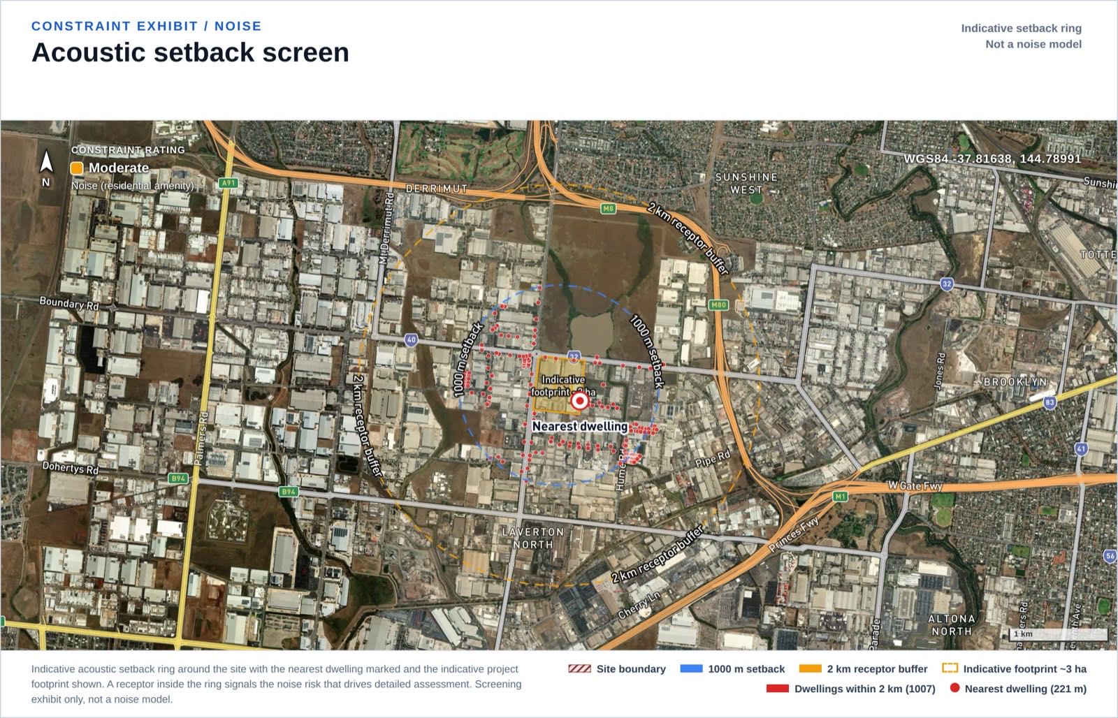
Noise and receptor exhibit from the same demonstration report: dwellings around the site, nearest at 221 m. A noise assessment must consider all receptors in the area, not only the closest.
The lesson: check the zone before you check the substation
From above, Melbourne's west looks like one continuous industrial belt. On the cadastre it is UGZ growth-front land, PCRZ conservation reserves and mapped heritage-sensitivity areas interleaved with genuine IN2Z industrial land, sometimes on adjoining parcels. Every metro industrial belt in Australia has a version of this. Satellite imagery cannot distinguish any of it; the planning layers can.
The Victorian heritage trigger from parcel 1 surprises interstate developers, so it is worth spelling out. Under the Aboriginal Heritage Regulations 2018 (Vic), a Cultural Heritage Management Plan is mandatory when a listed high impact activity is proposed within a mapped area of cultural heritage sensitivity, and the planning permit cannot be issued until that plan is approved. Because the trigger is tied to mapped areas, a desktop screen catches it on day one; found late, it adds months.
What a data centre screen weighs differently
We added a data centre project type to the engine this month. The checklist is the same 19 constraints we run for BESS and solar sites; the interesting part is the weighting:
- Noise is weighted as continuous. A warehouse at 221 m from a dwelling barely registers acoustically; a data centre's cooling plant runs through summer nights, so noise holds at moderate until modelling clears it, whatever the separation.
- Standby diesel is a dangerous-goods problem, not a footnote. The principal on-site hazard is bulk diesel storage for standby generation, a dangerous good under AS 1940:2017, the Australian Standard for the storage and handling of flammable and combustible liquids. Quantities are typically below Major Hazard Facility thresholds but must be confirmed, and UPS battery rooms carry their own fire-safety standards. Air quality runs parallel: no continuous combustion, but generator testing produces intermittent emissions, and EPA licensing depends on the installed generator capacity.
- The connection is a major load, not a generator. The approvals pathway ends with a connection application to the distribution or transmission network operator for a new high-voltage load. No generation licence, and none of the generator-side registration a BESS screen carries.
The assessment pathway also splits by state, and recent approvals show both routes working. In NSW, a data centre with total power consumption above 15 MW is State Significant Development; the threshold came in at 10 MW in June 2021 and moved to 15 MW on 1 June 2023. The NEXTDC S4 campus at Horsley Park (SSD-63741210), six buildings and roughly 250 MW, was approved on that pathway on 24 December 2025. In Victoria, the Development Facilitation Program gives an expedited ministerial pathway, with the significant economic development class covering data centres with an estimated development cost of at least $20 million in metropolitan Melbourne. The West Footscray data centre at 63 Sunshine Road (PA2403320) was decided that way, by ministerial permit on 4 April 2025.
The survivor's 19 constraints, in full
The complete constraint table from the surviving site's report, exactly as the engine rated it. Data status is recorded separately from the rating: "data limited" means not desktop-assessable and needing a specialist, which is not the same as low risk.
| Constraint | Rating | Data status |
|---|---|---|
| Zoning | Insignificant | Assessed, clear |
| Cadastral / Title & Easements | Moderate | Constraint found |
| Planning Overlays | Insignificant | Assessed, clear |
| Aboriginal Heritage | Minor | Assessed, outside sensitivity area |
| Historic / Federal Heritage | Insignificant | Assessed, clear |
| Bushfire | Insignificant | Assessed, clear |
| Flora & Fauna / Ecology | Moderate | Constraint found |
| EPBC / Matters of National Significance | Moderate | Constraint found |
| Hydrology / Flooding | Insignificant | Assessed, clear |
| Noise (residential amenity) | Moderate | Constraint found |
| Visual Amenity | Minor | Assessed |
| Contours / Topography | Insignificant | Assessed, clear |
| Geotechnical | Minor | Data limited, survey required |
| Soils | Insignificant | Assessed, clear |
| Utilities (power / gas / water / NBN) | Insignificant | Assessed |
| Traffic & Access | Minor | Data limited, TIA at DA stage |
| Contaminated Land | Insignificant | Assessed, clear |
| Air Quality | Minor | Assessed (project-type rule) |
| Hazard & Risk (fire / explosion) | Minor | Assessed (project-type rule) |
Even the "insignificant" rows carry facts: utilities found a gas pipeline 370 m away and a water and sewer main within 23 m, and flooding noted the site is very flat (about 0.6% grade), so internal stormwater drainage is a design job despite no mapped flood hazard.
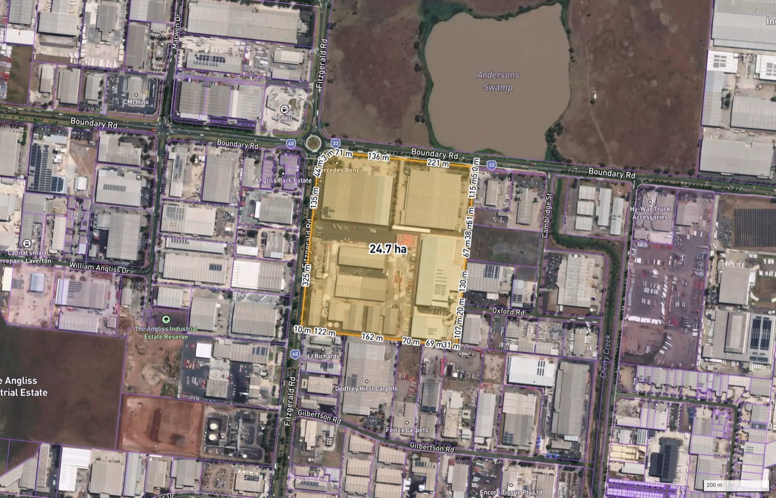
Constraint context exhibit from the demonstration report: the mapped planning and environmental context around the surviving parcel.
What this screen is, and is not
Being clear about the edges of the tool is part of the point:
- It is a desktop screen. A$1,000 per site on the pilot, one business day, 19 constraints, delivered as a report like the live sample. It exists to kill bad sites cheaply and scope specialist work on good ones; it is not planning advice and does not replace consultants, surveys or a title search.
- It has no grid hosting capacity or fibre data. Those assessments happen with the network operator and carriers; nothing in our report substitutes for them.
- Missing data is flagged, never assumed clear. Geotechnical and traffic are never desktop-assessable and are marked data limited. In some states whole layers are restricted: NSW Aboriginal heritage (AHIMS) cannot be queried and NSW council flood mapping is partial, so those constraints return "pending" there rather than a fake green tick. The Victorian demo above happened to reach 19/19 at 100% completeness; every report states its own.
- EPBC is screened by mapped matters and referral proximity. A Protected Matters search and formal self-assessment are still required; the report says so.
If you are shortlisting data centre land, the free two minutes are the zone and overlay check on the map; the paid day is the full 19-constraint screen, described at /solutions/data-centre-site-screening/. Three of our own four candidates failed it. That is the best argument for running it first.
FAQ
What zoning do you need for a data centre in Australia? Industrial zonings are the natural home; our surviving parcel was IN2Z (Industrial 2 Zone) in Victoria. The traps are parcels that look industrial but sit in growth zones (UGZ) or conservation zones (PCRZ), where the use may be premature or prohibited. Check the zone first; it is free on our map.
When does a data centre need State Significant Development approval in NSW? When its total power consumption exceeds 15 MW, the project is assessed as State Significant Development rather than by the council. The threshold was introduced at 10 MW in June 2021 and moved to 15 MW on 1 June 2023. The NEXTDC S4 approval at Horsley Park in December 2025 is a recent example.
Is there a fast-track planning pathway for data centres in Victoria? Yes, the Development Facilitation Program provides an expedited ministerial pathway, and its significant economic development class covers data centres with an estimated development cost of at least $20 million in metropolitan Melbourne. The West Footscray data centre (PA2403320) was approved this way in April 2025.
Does a data centre trigger a Cultural Heritage Management Plan in Victoria? It can. A CHMP is mandatory when a listed high impact activity is proposed within a mapped area of cultural heritage sensitivity under the Aboriginal Heritage Regulations 2018, and the planning permit cannot issue until the plan is approved. One of our four screened parcels sat inside a mapped sensitivity area; the screen caught it in minutes.
What does a data centre site screen check, and what does it cost? It runs 19 planning and environmental constraints against a drawn site boundary: zoning, overlays, heritage, ecology, EPBC, flooding, noise receptors, easements, utilities, contamination and diesel-storage hazard among them. A$1,000 per site on the pilot, one business day. It is a desktop screen for site selection, not planning advice.
Does the screen cover grid hosting capacity or fibre? No. We do not hold grid capacity or fibre route data and say so, rather than dressing up proximity as capacity. The screen covers the planning layer, where three of our four test parcels failed; power and connectivity sit with the network operator and carriers.


