
Industrial land looks like the easiest asset class to screen: flat, zoned, serviced, surrounded by other sheds. What could a planning screen possibly add?
That assumption is exactly why warehouse applications get stuck. On industrial land the constraints sit under the concrete: an easement that dictates the building envelope, remnant grassland with national-significance listings across the fence, an address point 109 m away that may or may not be a dwelling, and a freight task the road authority will treat as the main event. None of it is visible on satellite. All of it is checkable from a desk on day one.
This guide works through a real example: a 2.9 ha industrial infill lot in Laverton North, in Melbourne's west, which our production engine assessed against 19 planning and environmental constraints this month while we built our warehouse screening service. The parcel is real, screened as a demonstration, not a client project or a proposal for that land. That is what makes it useful: we can show everything the screen found.
The zone trap: what the satellite cannot see
From above, a metro industrial belt looks like one continuous carpet of grey roofs and cleared pads. On the cadastre it is nothing of the sort.
We probed several parcels across Melbourne's west that read as ordinary industrial belt on imagery. Two parcels in Ravenhall came back from the zone query as Special Use zones (SUZ1 and SUZ8), not industrial zones at all. We did not chase down what those schedules provide for; the point is that satellite imagery cannot tell you a schedule exists, let alone what it permits. Another parcel, in Laverton North itself, returned PCRZ, the Public Conservation and Resource Zone: a conservation reserve wearing an industrial landscape. Our data centre site selection in the same corridor hit the same pattern; the full four-parcel story is in the data centre screening write-up.
The zone attribute is the cheapest item on the checklist, and the only constraint that can kill a site with a single word.
The worked example: 2.9 ha in Laverton North, IN2Z
Our demonstration site is zoned IN2Z (Industrial 2) in the City of Wyndham, at 2.9 ha the scale a single-facility warehouse actually gets built on. The engine assessed all 19 constraints at 100% data completeness and returned "No fatal flaws identified": 0 major, 5 moderate, 5 minor, 9 insignificant, 0 pending. The full output is live as a sample report.
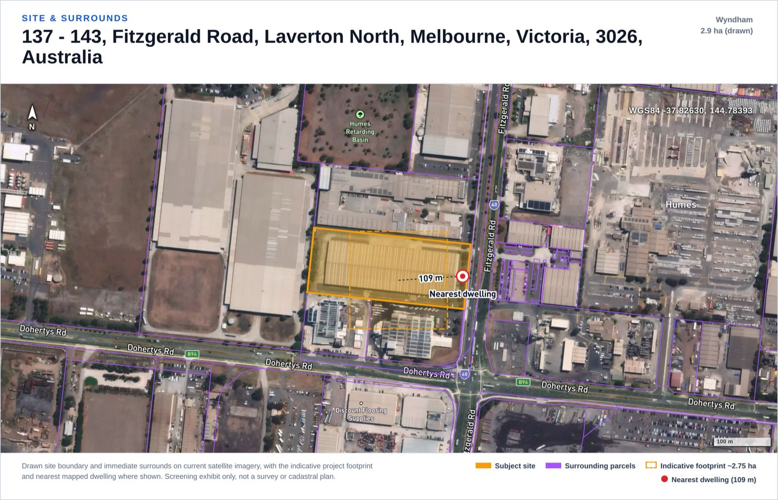
Site and surrounds exhibit from the screening report our engine generated on this real parcel as a demonstration (not a client project or a proposal for that land).
The risk score is where honest reading matters. The site scored 50/100, landing in our "Heavily constrained" band, a label that sounds worse than the verdict until you see behind it. Nothing on the list threatens viability; the score is high because five constraints came back moderate, each a scoped specialist workstream on the path to lodgement. The band is a workload meter, not a prediction of refusal.
The five moderates:
- Traffic and access. Rated moderate by a project-type rule, not measured data. In the engine's words: "Freight / logistics use: operational heavy-vehicle traffic is intrinsic and a Traffic Impact Assessment with intersection modelling is required."
- Title and easements. An infrastructure corridor crosses the lot: a 66 kV transmission line runs within 50 m and a gas transmission pipeline within 24 m. Such corridors carry registered easements and setbacks that constrain where the building can go, so the Certificate of Title comes first. (Background: our transmission line guide.)
- Flora and fauna. Threatened biota is mapped in the area, and the Angliss Grassland (Laverton North) Nature Conservation Reserve sits about 478 m away. This is volcanic plain grassland country, and remnants survive inside the industrial estate.
- EPBC. A Matter of National Environmental Significance is likely triggered and a referral required: the same grassland at Commonwealth level. A Protected Matters search and self-assessment follow.
- Noise. The nearest address point is about 109 m away. The story is in the next section.
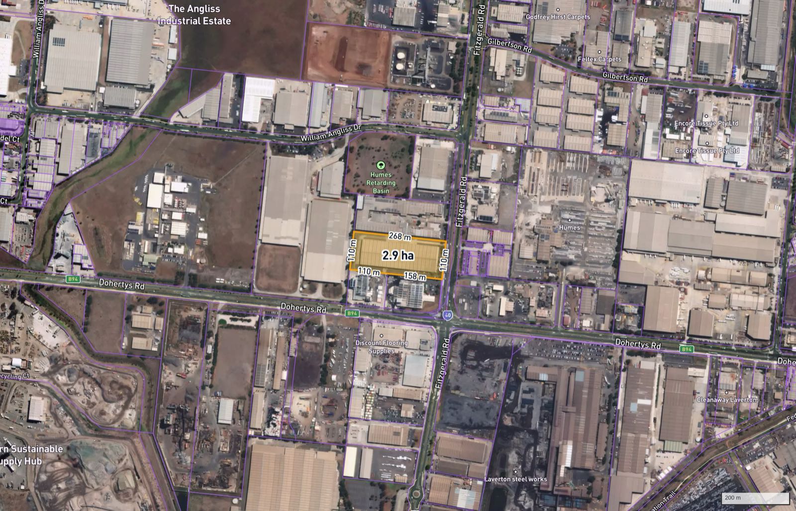
Constraint context exhibit from the same demonstration report: infrastructure corridors and the grassland reserve context.
The full 19-row result, exactly as the screen rated it:
| # | Constraint | Rating | What the screen found |
|---|---|---|---|
| 1 | Zoning | Insignificant | IN2Z (Industrial 2), compatible |
| 2 | Cadastral / title & easements | Moderate | Corridor crosses the lot; title required |
| 3 | Planning overlays | Insignificant | None intersect the site |
| 4 | Aboriginal heritage | Minor | Outside mapped cultural heritage sensitivity |
| 5 | Historic / federal heritage | Insignificant | No listed place within 1 km |
| 6 | Bushfire | Insignificant | Not in a mapped bushfire prone area |
| 7 | Flora & fauna / ecology | Moderate | Threatened biota; Angliss Grassland NCR about 478 m |
| 8 | EPBC / MNES | Moderate | Likely triggered; referral required |
| 9 | Hydrology / flooding | Insignificant | No mapped hazard; flat grade is a drainage design matter |
| 10 | Noise (residential amenity) | Moderate | Nearest address point about 109 m; may be non-residential |
| 11 | Visual amenity | Minor | Site higher than 71% of surrounding sample points |
| 12 | Contours / topography | Insignificant | Mean slope about 1.4% |
| 13 | Geotechnical | Minor (data limited) | Not desktop-assessable |
| 14 | Soils | Insignificant | No acid sulfate or reactive soils mapped |
| 15 | Utilities | Insignificant | 66 kV within 50 m; gas 24 m; water/sewer 30 m |
| 16 | Traffic & access | Moderate (data limited) | Freight task intrinsic; TIA required |
| 17 | Contaminated land | Insignificant | No EPA-listed site within 500 m |
| 18 | Air quality | Minor | Construction dust only |
| 19 | Hazard & risk (fire / explosion) | Minor | Set by what is stored (see below) |
Row 19 deserves a sentence. A warehouse's on-site hazard is set by what it stores, which no desktop can know: general freight carries no significant fire or explosion hazard, while dangerous-goods storage triggers licensing, separation and placarding requirements under state dangerous goods legislation. The screen names that check instead of guessing at a tenant.
The address point 109 m away, and why we did not call it a dwelling
The noise finding is where an automated screen most easily goes wrong, in both directions. The raw geometry says 1,130 GNAF address points within 2 km, the nearest about 109 m from the site. Feed that to a naive rule and this lot fails on residential encroachment. But the nearest point is a unit address inside the neighbouring industrial complex, and GNAF points in industrial estates are mostly factory units, not homes. A screen that calls every factory unit a dwelling cries wolf on every infill lot in the country. The opposite failure is worse: silently dropping address points it cannot classify means one day dropping a caretaker's flat that is a real receptor, discovered at the objection stage.
Our engine took the middle path. It capped the rating at moderate instead of major and printed its reasoning next to the number: the point may be non-residential, the nearest mapped residential zone is about 5 km away, confirm whether it is an occupied dwelling before relying on the rating. One site visit or phone call resolves it. The screen's job was to put that check on the list with the distance attached, not to fake certainty it does not have.
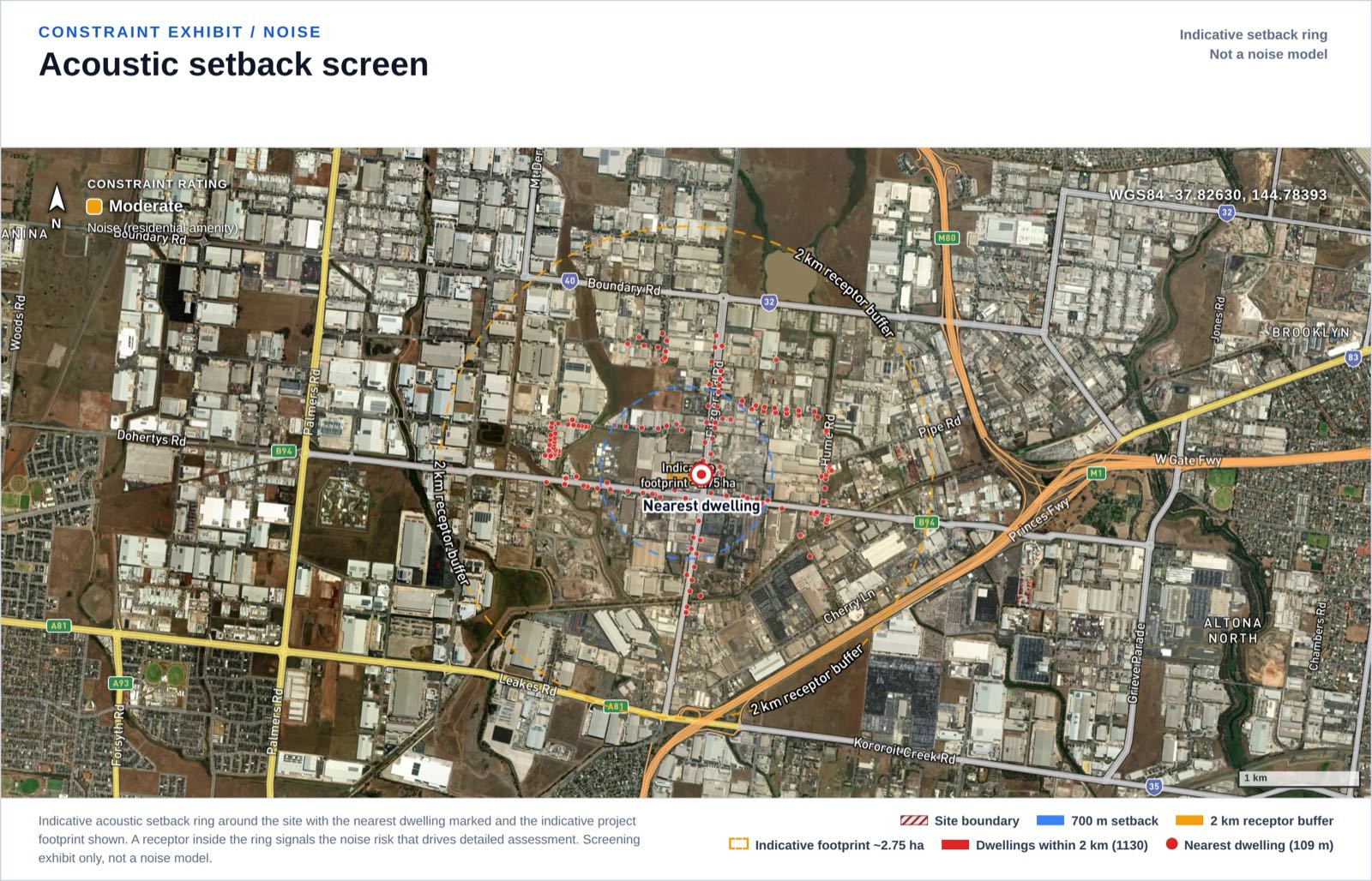
Receptor exhibit from the demonstration report: address points around the site, nearest about 109 m. Most are industrial unit addresses, which is why the screen names the check instead of assuming.
Freight is the assessment, not a footnote
For most project types, traffic is a construction-phase item: trucks during the build, then quiet. A warehouse inverts that: dock cycles, line-haul and last-mile movements, often across extended hours, are the facility's purpose, so the engine rates traffic moderate for freight and logistics uses by rule, before any data is queried.
That is a deliberate honesty choice. We hold no traffic counts for this site, and the report says so: the constraint carries a data-limited flag rather than a clean rating. The real answer lives in a Traffic Impact Assessment with intersection modelling, swept paths and route confirmation with the road authority. The screen's contribution is sequencing: for this asset class the TIA sits on the critical path from day one.
Where warehouse applications are happening
Filtering our 848,604-record development application database for warehouse, distribution centre and logistics facility keywords returns 4,796 applications: NSW 1,518, SA 1,331, QLD 1,271, VIC 530, ACT 103. The busiest councils are Brisbane City (645), the City of Casey (333) and Port Adelaide Enfield in SA (300), then Logan City (234).
DA Leads database snapshot, queried 2026-07-12.
Read those as records in our database, not market totals: our scraper history means pre-2021 years are sparse, and coverage varies by state. The bigger caveat is structural: these are council-lodged applications, and the biggest projects never appear in a council list. In NSW, a warehouse or distribution centre with a capital investment value above $50 million is assessed by the state as State Significant Development, not by the council; the threshold was $30 million when the pathway was introduced and rose to $50 million from 1 June 2023. Both precedents in our demonstration report ran that pathway at Kemps Creek in Western Sydney: the Aspect Industrial Estate (SSD-10448, concept consent 24 May 2022) and a roughly 30 ha estate approved 28 July 2025. The council DA stream is the single-facility and infill end of the market, exactly the scale of our 2.9 ha example.
What a screen can and cannot tell you
Being clear about limits is the product:
- A desktop screen is not planning advice. It does not replace a planning consultant, ecologist or traffic engineer. Its job is to find fatal flaws before you spend on them, and to sequence them when you do.
- Data-limited constraints are named, not hidden. Geotechnical conditions and the freight task cannot be assessed from a desk; the report flags both.
- Title detail needs the title. Mapped easements told us a corridor crosses this lot; only the Certificate of Title gives the registered terms, width and beneficiary.
- EPBC screening is by proximity and mapped layers. A Protected Matters Search Tool report and self-assessment are still required.
- Mapped boundaries are generalised. Distances like 109 m and 478 m are indicative, not survey-accurate.
The screen is A$1,000 per site, returned in one business day, covering all 19 constraints with every rating traceable to a named data source; the specialist studies it sequences cost tens of thousands each. Details are on the warehouse site screening page, the full worked output is the sample report, and the zone check that starts everything is free on the map.
FAQ
What zoning do I need for a warehouse in Australia? Each state names its zones differently; the Laverton North example sits in Victoria's IN2Z (Industrial 2). Metro industrial belts interleave Special Use zones, conservation reserves and growth-zone land with genuine industrial parcels. Check the exact lot's zone, free, on our map first.
When does a warehouse become State Significant Development in NSW? When its capital investment value exceeds $50 million, the application is assessed by the state as SSD rather than by the council. The threshold was $30 million when the pathway was introduced and rose to $50 million from 1 June 2023.
Why did the screen rate this site "Heavily constrained" if it found no fatal flaws? The band measures workload, not viability. The site scored 50/100 on five moderate constraints, each a scoped specialist workstream, with zero majors and zero pendings. A heavily constrained site can still be the right site; the score tells you what it costs to reach lodgement.
Do I need a Traffic Impact Assessment for a warehouse DA? For a freight or logistics use, plan on it. Operational heavy-vehicle movements are intrinsic to the asset, so our screen rates traffic a moderate, primary assessment matter by rule. The real answer comes from a TIA with intersection modelling and route confirmation with the road authority.
Why was the nearest "dwelling" not treated as a major noise constraint? The nearest GNAF address point sits about 109 m away, but it is a unit address inside the neighbouring industrial complex and the nearest mapped residential zone is about 5 km away. The screen capped the rating at moderate and named the check: confirm whether the point is an occupied dwelling before relying on the rating.
Does a desktop screen replace planning and environmental consultants? No. It finds fatal flaws before feasibility spend and sequences the specialists you still need. The specialist reports remain the consultants' work, and a development application still requires them.


